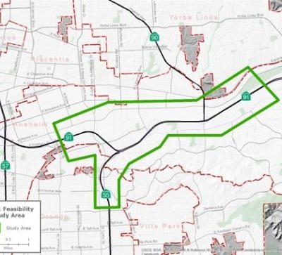
The study area for the SR-91 TSR extends from west of Tustin Avenue to east of Imperial Highway and includes SR-55 from the SR-91/SR-55 connector to south of Lincoln Avenue. There are four project alternatives for the build out year of 2025: No Build, Option 1A, Option 3, and Option 3L.
No-Build
The No-Build alternative or option incorporates funded projects that are currently being constructed or environmentally cleared as part of the Caltrans PSR-PDS.
Option 1A
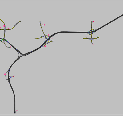
This option realigns the westbound SR-91 to southbound SR-55 connector with an elevated structure to connect to westbound SR-91 on the inside lane and to southbound SR-55 on the right-hand side. Currently, SR-91 and SR-55 traffic are mixed among the five mainline lanes and must weave past the Lakeview Avenue interchange to reach their respective destinations.
This option would require SR-91 and SR-55-bound traffic to segregate east of the Lakeview Avenue interchange, just west of the Lakeview Avenue off-ramp. Traffic to the southbound SR-55 connector from Lakeview Avenue would use the newly constructed loop on-ramp to join traffic heading to SR-55 on the right side of the freeway. SR-91 westbound traffic would enter from the new diagonal Lakeview Avenue on-ramp to cross under the SR-55/Lakeview Loop on-ramp structure to continue onto the SR-91. All three westbound on- and off-ramps will be reconfigured so that northbound and southbound traffic on Lakeview Avenue can access the respective freeways.
Option 3
This option also realigns the westbound SR-91 to southbound SR-55 connector with an elevated structure to connect to westbound SR-91 on the inside lane and to southbound SR-55 on the right-hand side. However, a new diagonal on-ramp would join the SR-55-bound traffic on the right-hand side while a new median drop-ramp would join SR-91 traffic to proceed to westbound SR-91. The existing loop on-ramp will be eliminated while the westbound off-ramp will also be reconfigured.
Option 3L
Option 3L would have the same existing configuration with the SR-55 connector located on the left-hand side of the SR-91 freeway. Similar to the other two options, SR-91 and SR-55 traffic would separate east of the Lakeview Avenue interchange. A new drop ramp will be constructed between the SR-91 and SR-55 lanes for access from Lakeview Avenue to the SR-55 connector while a diagonal on-ramp will be constructed on the right-hand side to provide access to traffic heading to SR-91 from Lakeview Avenue. Similar to Option 3, the existing loop on-ramp will be eliminated and the westbound off-ramp will be reconfigured.
The modeling area for the Feasibility Study extends from west of the SR-91/Tustin Interchange to east of the SR-91/Imperial Highway Interchange and includes SR-55 from the SR-91/SR-55 connector to south of Lincoln Avenue. The model was built based on an existing SR-91 corridor TransModeler micro-simulation model we developed for the Caltrans District 12 SR-91 Corridor System Management Plan (CSMP) study completed in 2010. The model was recalibrated against Year 2011 traffic condition. There are a total of 19 traffic analysis zones in the model.The OCTAM travel demand model was used as the reference OD table to estimate the demands for the model.
The micro-simulation model evaluated the operational performance measures for each of the design options for the peak periods between 6:00 AM through 9:00 AM and 3:00 PM through 7:00 PM. Using the model analysis, the following performance measures were assessed:
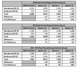
For each scenario, the study team added the proposed improvements, conducted multiple model runs, and produced composite results by facility type (i.e., mainline, High Occupancy Vehicle [HOV], and ramps) and vehicle type (Single Occupancy Vehicle [SOV], HOV, and trucks). As shown in the figure, option 3L produces the best overall results with a delay reduction of 34% from the No Build, whereas the other two options yield a modest reduction of up to 7%. Delay summary can be found in the table below.
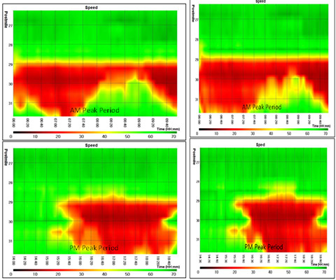
The speed contours from the Base and Horizon year are as shown in figures below.
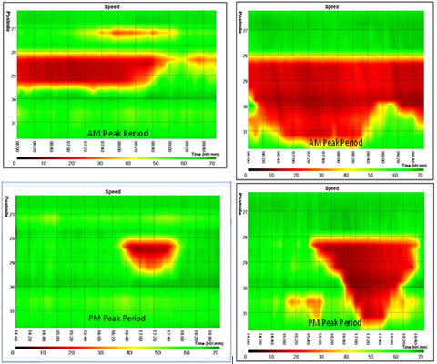
The speed contours for different scenarios are shown below.
Sponsored by Orange County Transportation Authority (OCTA)
Primer Contractor: RBF
Project period: March 2015 to December 2015