CLR is a leading micro-simulation consultant in the world. Based on many academic research and practical projects conducted since the late 1990s, consultants at CLR are proficient and have extensive experiences using the most popular microsimulation packages, including Paramics, TransModeler, and Vissim, for the following application areas.
We are not only skillful in building simulation models and performing alternative analysis, but also experts in the behavioral algorithms inside of the microsimulation models. Some of our research papers are highly-cited by the traffic simulation community and used as guidelines and references in various applications. We have a close relationship with simulation software developers and have been collaborating with them on consulting projects and software functionality enhancements. We are the major microsimulation (including Paramics, TransModeler, and Vissim) plugin developer in the world. Our plugins have been used by top consultants, universities, and government agencies.
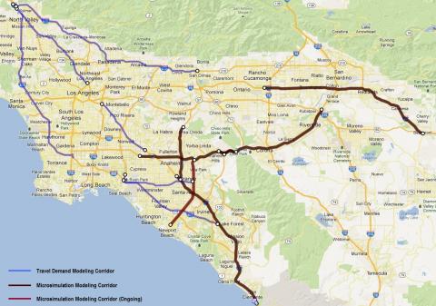
From 2007 to 2012, CLR has been a major force in conducting travel demand modeling tasks, developing traffic simulation models, and performing traffic operations analysis for the CSMP projects. The travel demand modeling tasks were performed on 12 corridors using either the Southern California Association of Governments (SCAG) travel demand model or the Orange County Transportation Authority Model (OCTAM) under the TransCAD platform. Both models have been significantly improved through updating network geometry data for study corridors and enhanced through a few GISDK functions CLR developed for corridor studies. In addition, CLR performed detailed modeling studies for five CSMP projects using different traffic simulation packages (e.g., Paramics for SR 57 and I-5 in Orange County, Vissim for I-10 in San Bernardino County and SR 91 in Riverside County, and TransModeler for SR 91 in Orange County). All these comprehensive studies include heavy-duty data collection and analysis, OD estimation based on the regional travel demand model, microsimulation model calibration, and evaluation of alternative scenarios based on Base and horizon demands.
.
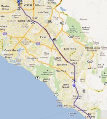
CLR Analytics Inc. worked as a subcontractor of CH2M Hill to complete the Orange County Managed Lane Network Study. In the study, CLR Analytics developed a Paramics simulation model (based on the I-5 Corridor System Management Plan (CSMP) model) to demonstrate the managed lane concept using the I-5 network from SR-55 to SR-57.
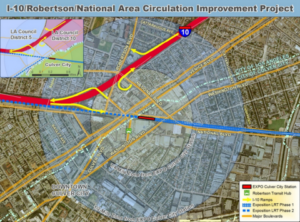
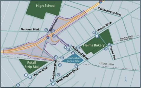
The project aims to study ways to improve the Robertson / National on/off ramps and the connectors to local streets, simplify traffic movements and minimize traffic impacts from the Culver City Expo station and other new development in the area. The CLR modeling team developed the base year microsimulation model, which was well calibrated against the 2016 traffic condition. Then, the microsimulation models for four different design alternatives were developed for both AM and PM peak hour and their performance was optimized to maximize the number of vehicles to be served.
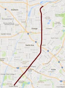
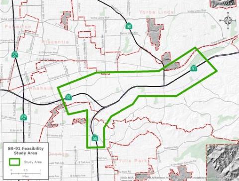
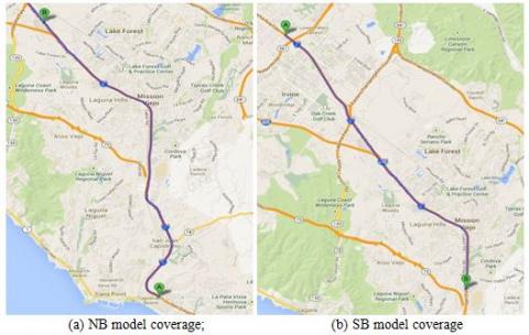
SR-55 is major north-south freeway corridor in Orange County, extending from the 19th St. intersection to the SR-91 interchange. Within the study corridor, there are a number of major freeway-to-freeway system interchanges, including SR-73, I-405, I-5, SR-91 and SR-22. The corridor has three to five mixed-flow lanes and one HOV lane with full-time continuous access along most sections. The corridor primarily consists of commuter traffic, and therefore, typical weekday morning and afternoon peak periods are of concern. In order to fully evaluate the characteristics of congestions, the microsimulation model is setup to capture pre-congestion, during congestion, and after congestion conditions of each peak period.
In this project, CLR tested the FreeVal tool from the SHRP2 L38 toolset using the I-5 study site, which we have a well-calibrated microsimulation model developed for another project and thus also we were very familiar with the traffic condition. FreeVal-RL is an excel based tool to evaluate the reliability based on macroscopic traffic flow model. It is the most complex tool among all reliability tool sets from SHRP2. Although it is designed to be a simple tool for end users because of the use of Excel as the model platform, we found that it was not easy to use, especially for a complicated network with multiple lanes and both mixed-flow and carpool lane facilities. With the help from the developer, we managed to devlop the model inputs as shown below.

The rapid development of automated vehicles has attracted a lot of attentions from the public in recent years. Current studies on automated vehicles mainly focus on microscopic simulations with simple network topologies and driver behaviors, and few has considered to incorporate automated vehicles into macroscopic travel demand models for the analysis in a regional network. In this project, we propose an Automated Vehicle System Impacts Evaluation Module, AVSIEM, for both transportation and traffic operation analysis using a two-step multi-resolution modeling approach. The approach involves the use of microsimulation to quantify the capacity improvement through a capacity adjustment factor (CAF), which is then applied in the macroscopic travel demand model
I-5 is a major North-South freeway corridor connecting Orange County and Los Angeles (LA) County. The corridor has four to five mixed-flow lanes and one HOV lane with full-time limited access along most sections. The study area is approximately 34 miles in length between the Chapman interchange in the north and San Diego/Orange County Line in the south. There are a number of major freeway-to-freeway system interchanges, including SR-73, SR-133, I-405, SR-55, SR-22, and SR-57. The corridor has good detector coverage, which has been installed to freeway mainline, on-ramps, and off-ramps. The corridor primarily consists of commuter traffic, and therefore, typical weekday morning and afternoon peak periods are of concern. The I-5 microsimulation model was built under Paramics v6.8.1 and was expected to reflect the typical traffic condition in the Fall quarter of Year 2010. The study area includes all freeway-to-freeway connectors of major interchanges, ramp terminal intersections, as well as adjacent arterial intersections.
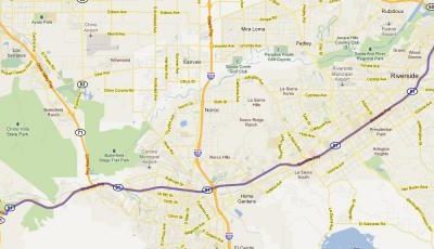
The study site is SR-91 corridor, which is 25-mile long from the SR-60/I-215 interchange in the west to SR-241 interchange in the east. It has four to five mixed-flow lanes. Within the study corridor, there are two other major freeway-to-freeway facilities, which are SR-241, I-15 and SR-60/I-215. The SR-91 is a major East-West corridor connecting the Riverside County with Los Angeles and Orange Counties. It serves most daily commuters travelling westbound to Los Angeles and Orange County for work during the AM and travelling back to the Riverside County during the PM.