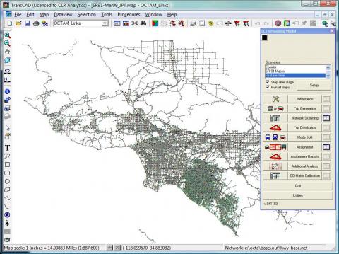
CLR has a world-class team specialized in travel demand modeling, traffic simulation modeling, and their various applications. We build travel models from scratch using travel survey data. We are proficient at several modeling tools including TransCAD, Cube Voyager, VISUM, and EMME. We are currently maintaining a customized version of Southern California Association of Governments (SCAG) travel demand model, i.e., the Orange County Transportation Authority Model (OCTAM) under the TransCAD platform.
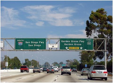
The study site is the whole SR-22 (State Route 22) and I-405 (Interstate 405) corridors in Orange County. The SR-22 corridor runs along the east-west direction and is approximately 15 miles long. The west end of the corridor intersects San Gabriel River and I-605, while the east end intersects SR-55. The I-405 corridor runs along the north-south direction and is approximately 34 miles long running from the Los Angeles and Orange County Line to the I-405/I-5 interchange.
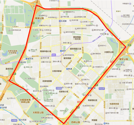
This is a joint work with Beijing Doquick Engineering to develop a simulation platform for the North China University of Technology. The simulation platform aims to use the OpenStreet Map as the web-based interface to display simulation/modeling results from different levels of modeling tools, including Macro (TransCAD), Meso (DynaChina), and Micro (Paramics and Synchro). For each modeling/simulation software, plugins and interface program are developed accordingly. The study site is the Wangjing area in Beijing. According to Dr. Li Wang, Dean of College of Electrical and Control Engineering, the simulation platform will significantly enhance the simulation capabilities of Beijing Key Laboratory on Urban Traffic Control Technology and the education of the traffic courses of the university.
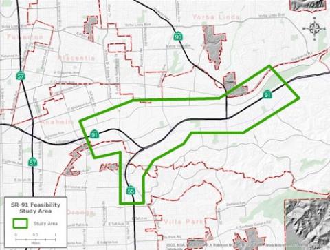
The study area of the SR-91 PSR extends from the west of Tustin Avenue to the east of Imperial Highway (SR-91) and includes SR-55 from the SR-91/SR-55 connector to the south of Lincoln Avenue. There are four project alternatives for the build-out year 2025: No Build, Option 1A, Option 3, and Option 3L.
Option 1A
This option realigns the westbound SR-91 to the southbound SR-55 connector with an elevated structure to connect to westbound SR-91 on the inside lane and to southbound SR-55 on the right-hand side. Currently, SR-91 and SR-55 traffic are mixed among the five mainline lanes and must weave past the Lakeview Avenue interchange to reach their respective destinations. This option would require SR-91 and SR-55-bound traffic to segregate east of the Lakeview Avenue interchange, just west of the Lakeview Avenue off-ramp.

The rapid development of automated vehicles has attracted a lot of attention from the public in recent years. Current studies on automated vehicles mainly focus on microscopic simulations with simple network topologies and driver behaviors. Few have considered incorporating automated vehicles into macroscopic travel demand models for the analysis in a regional network. In this project, we propose an Automated Vehicle System Impacts Evaluation Module, AVSIEM, for both transportation and traffic operation analysis using a two-step multi-resolution modeling approach. The approach involves the use of microsimulation to quantify the capacity improvement through a capacity adjustment factor (CAF), which is then applied in the macroscopic travel demand model.
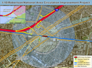
The Michael Baker International team, with SMG and CLR Analytics as a modeling and simulation subcontractor, won LADOT’s I-10 Robertson National Circulation Improvement Project. CLR modelers will use travel demand modeling and traffic simulation tools to test different design scenarios for the project.
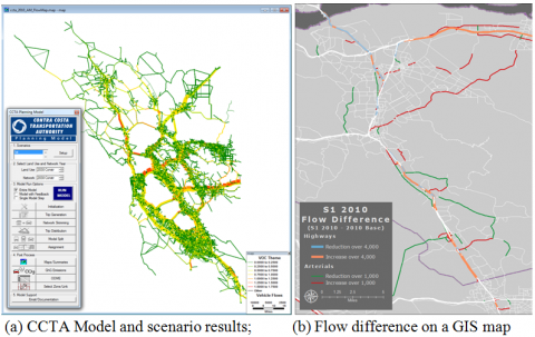
The project involved the use of Contra Costa Transportation Authority (CCTA) travel model to provide demand input data to TOPL and to evaluate the impacts of various projects on arterial diversion and freeway performance. The study corridor is the stretch of I-680 corridor between I-580 in the south and the Solano county line in the north. The challenge of the project is how to model the currently deployed HOT facilities and some upcoming HOT facilities that will be converted from HOV lane in future scenarios since there is no toll demand estimation and analysis module in the model. The approach taken is to treat HOT lane as a parallel facility of GP lanes, which is open to all vehicle classes but with a little bit cost that needs to be fine-tuned for reasonableness. The cost of HOT lane is determined when the HOT lane reaches but does not exceed its maximum capacity, which is 1600 vehicles per hour per lane. In other words, it is assumed that the HOT lane will be operated under the ideal condition. Then, the flow difference on the HOV/HOT lane before and after the conversion can be further post-processed to obtain the toll flows based on different toll policy.
Caltrans Corridor System Management Plan (CSMP) project aims to develop a CSMP plan that identifies system management strategies to relieve the traffic congestion problems occurred on the highways. The key tools used in the CSMP studies include microscopic simulation and travel demand forecasting models. The travel demand forecasting model is employed to extract the reference demands for the microsimulation modeling area, estimate OD demands, analyze travel demand patterns of the study corridors, and perform macro level scenario testing. The purpose of this OCTAM model enhancement subtask was to improve and enhance the TransCAD version of OCTAM in order to meet the requirements of CSMP projects in Orange County (including I-5, SR 91, SR 57, SR 55, SR 22/I-405).
The study site is I-405 in Los Angeles County, California. It is 36 miles in length stretching between the I-110 interchange (CA PM 12.5) and the I-5 interchange (CA PM 48.5). Our tasks for the study include demand extraction from the SCAG travel demand model for microsimulation, ramp metering setup in the Paramics simulation models, and the analysis of the travel pattern of trips made on the corridor through a select link analysis.
The study area for this project is divided into two parts. The southern part starts at CA post mile 0.000 (OC/LA line) to CA post mile 13.784 (I-710). The northern part starts at CA post mile 18.452 (I-10) to CA post mile 44.014 (I-210). The study aims to determine the travel pattern of trips made on the corridor using the SCAG travel demand model. A select link analysis was performed to isolate the I-5 study corridor and identified the origins and destinations of trips made on the corridor.
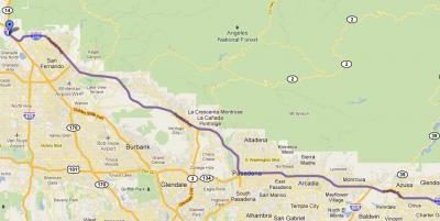
The study site is I-210, which is 45 miles long between the I-5 interchange (CA PM 0.0) and the SR-57 interchange (CA PM 45.0) in Los Angeles County, California. The study aims to determine the travel pattern of trips made on the corridor using the SCAG travel demand model. A select link analysis was performed to isolate the I-210 study corridor and identified the origins and destinations of trips made on the corridor.