Pedestrians and bicyclists are vulnerable in vehicle crashes. To improve the safety of pedestrians and bicyclists at intersection crossing, in this project, we will develop a traffic signal alert system that will integrate sensory information commonly available on a Smartphone, geographical information of an intersection, and real-time traffic signal information to alert or support decision making for pedestrians and cyclists. The system consists of a Smartphone application and a real-time traffic signal information service. The Smartphone application uses GPS, accelerometer and digital compass together with external digital maps to determine user location and orientation.
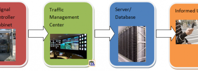
The application will also obtain real-time traffic signal phasing and timing from local signal controller or Traffic Management Center (TMC). Signal information or alert can be provided to users through configurable user interfaces (e.g., visual, speech, or vibrotactile) depending on user’s need or preference. The Smartphone application is meant to be a walking assistant, providing information to users at intersections to improve their safety. The safety benefits toward the visually impaired and the elderly people are obvious. They generally have difficulty crossing intersections due to the lack of information available to them about traffic signal and geometry at intersections. General pedestrians and cyclists will benefit from the information via the Smartphone application, particularly in unfamiliar environments. There are also significant benefits for sighted pedestrians or cyclists that may be distracted (e.g., talking or texting on their phones) while at the signalized intersections.
Smartphones, such as iPhones, Android and Blackberry phones, are more and more popular. Positioning, digital maps, and motion sensors equipped on these Smartphones together with advancement in wireless and cellular technologies have offered unprecedented opportunities for providing Location Based Services (LBS) to individuals. An increasing number of third-party Smartphone applications are being developed to provide entertainment, convenience, and information. The Smartphone is becoming an ideal platform for traffic applications. Some examples include navigation systems such as Navigon, Tomtom, and Waze and traffic information applications such as Google Map Traffic, Beatthetraffic, and Inrix traffic.
The Connected Vehicle Program, sponsored by the US Department of Transportation, aims to enable safe interoperable networked wireless communications among vehicles, the infrastructure, and passengers’ personal communications devices. The ongoing efforts from Connected Vehicle Program will define an open interface for two-way communication of intersections’ Geographic reference Information Data (GrID) and Signal Phase & Timing (SPaT) data between a traffic signal controller and a mobile device. With the GrID and SPaT data, a mobile device can potentially be utilized to assist intersection crossing.
The major tasks of this project include:
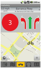
The system was developed based on surveys with potential users, including walking pedestrians, vision impaired pedestrians, and cyclists. Their needs and concerns while crossing intersections were identified and further analyzed for system development. The proposed system consists of a Smartphone application and a real-time traffic signal information service. A prototype Smartphone application was developed and tested under the Andriod platform to demonstrate the potential of the system. The functions of the Smartphone application includes determination of user’s location and orientation (using GPS, accelerometer and digital compass together with digital maps), judgment of user’s status (approaching, waiting at, or crossing an intersection), and provision of various alerts (e.g., visual, speech, or vibrotactile) to user through configurable user interfaces depending on user’s need or preference.
This project successfully shows that the proposed system is capable of complementing users’ basic information they can gather from their surroundings and encasing it with a plethora of information, which improves the safety at intersection crossing. The system can contribute significantly to the FHWA’s Connected Vehicle Technologies. Additionally, more functions can be added with the advent of new technologies such as improved positioning through Location-Based Services (LBS), advanced traffic signal controllers, text-to-speech conversion, Vehicle to Pedestrian (V2P) and Infrastructure to Pedestrian (I2P) communications through DSRC. Thus, the application will be able to attract more users, including both pedestrians and drivers. As a typical intersection safety application, successful deployment of the system will provide various types of pedestrians and cyclists with a safer intersection crossing environment by integrating emerging technologies.
Sponsor: USDOT/RITA/Volpe Center
Project Time Period: April 2011 – January 2012